Looking to get your heart rate up whilst exploring in Victoria? We’ve done the hard work for you and collated our favourite day hikes only a few hours from Melbourne with options for the new to seasoned adventurers.
You Yangs
Only an hour and half from Melbourne, the You Yangs have something for everyone, with a choice of hikes to suit all difficulty levels, plus incredible views reaching to Melbourne and Geelong, plus birdlife, mountain biking tracks and easy picnic spots.
Location: 60km south west of the city (50 min drive)
Flinders Peak Walk
Distance: 3.2km (1 hr return)
Level of difficulty: Hard
East-West Walk
Distance: 4.5km (2 hrs return)
Level of difficulty: Medium to hard
Find out more here.
Werribee Gorge
Werribee Gorge is a favourite for a reason, offering incredible views of the gorge, (a little) rock climbing and if you’re keen, a mid-hike swimming hole. The Circuit track is the best for great river views and has steep climbs. Start at the Quarry and head around the track around the river and then towards the Eastern Lookout around the gorge rim for breathtaking views.
Location: 68km west of the city, (1 hr drive)
Werribee Gorge Circuit
Distance: 10km circuit (4 hrs)
Level of difficulty: Medium to Hard
Find out more here.
Lerderderg Gorge
The Lerderderg Gorder is a 300m deep gorge runs through the park’s sandstone and offers an enjoyable walk through native bush alongside the Lerderderg River. Start your walk at McKenzie’s Flat, a picnic area with toilets, BBQs, information signs and shelter.
Location: 131km north west of the city (1 hr 45min drive)
Mackenzie’s Flat to Graham’s Dam
Distance: 3.53km (1 hr)
Level of difficulty: Easy
Lerderderg Gorge
Distance: 8.5km (3 hrs)
Level of difficulty: Medium to hard
Find out more here.
Point Nepean, Cape Schanck
This Coastal Walk stretches out 30km between the Point Nepean National Park and Cape Schanck and is situated on the southern side of Mornington Peninsula. On the walk, you’ll get to walk past sandy beaches, rocky ocean coasts, gravel tracks as well as dense coastal vegetation. Several sections can be completed as shorter walks if desired. We recommend starting at Cape Schnack and walking west along the Bass Strait coast.
Location: 105km south east of the city (1 hr 15min drive)
Distance: 30km
Level of difficulty: Medium to Hard
Cape Schanck to Gunnamatta Surf Beach (Part of the Coastal Walk)
Distance: 4.5km (2.5 hrs)
Level of difficulty: Medium
Find out more here.
George Bass Coastal Walk
The George Bass Coastal Walk stretches from Punchbowl Road, at the outskirts of San Remo, to the Bass Highway in Kilcunda. You will be treated to amazing Bass Coast views and follow the voyage of explorer George Bass along the Anderson Peninsula from over 200 years ago. The walk takes around 2 hours (one way) to complete and requires small climbs over farm fences.
Location: 100km south east of the city (1 hr 30min drive)
Distance: 7km (2 hrs one way)
Level of difficulty: Medium
Find out more here.
Cathedral Ranges
There are a large variety of walks of all lengths and difficulty levels to do at the Cathedral Range State Park. You can take a pleasant walk along the Friends Nature Trail or challenge yourself to climb through the jagged ridges on the Razorback Track. There are also camping grounds for families and even overnight hikes for the more experienced walkers.
Location: 116km north east from the city (2 hrs drive)
Friends Nature Trail
Distance: 2km (1 hr circuit)
Level of difficulty: Easy
Neds Gully Track
Distance: 2.2km (1 hr one way)
Level of difficulty: Hard
Find out more here.
Hanging Rock
The Hanging Rock Summit Walk will treat you to gorgeous views of the northern region of Melbourne and interesting rock formations the whole way up. The walk can be quite a steep way up so we recommend taking your time with enough rest breaks on the way and also give yourself time to explore the rocks.
Location: 70 km north west of the city (1 hr drive)
Distance: 1.57km (25 mins)
Level of difficulty: Medium
Find out more here.
Point Addis
The Point Addis Marine National Park is full of beautiful cliff top views and sandy beaches alongside Victoria’s coastline. You’ll be treated to gorgeous scenery, limestone and sandstone cliffs, rocky platforms and rocky reefs. In the marine environment, you can also dip into the rockpools filled with marine life.
Location: 109km south west of the city (1 hr 30 min drive)
Distance: 3.17km (47 mins)
Level of Difficulty: Easy
Find out more here.
Toorongo Falls
Situated in Gippsland, the Toorongo Falls Reserve consists of some of Victoria’s gorgeous, cool temperature rainforests. There is also the Toorongo Falls Camping area perfect for families to camp for the night amongst the banks of the Toorongo River. You can see the beautiful falls from the viewing platform at the base where you can sit and take in the view. We recommend you also add the Noojee Trestle Bridge to your list, with it just a short drive away, offering impressive views from all angles and only a few hundred metres of walking. can be completed in 30 minutes.
Location: Noojee, 137km north east of the city (2 hrs drive)
Distance: Toorongo Falls Circuit walk is 2.2km (1 hr 30min)
Level of difficulty: Easy
Find out more here.
Keppel Lookout & Steavensons Falls
Challenge yourself with the Keppel Lookout Trail where you’ll climb through stringybark forest, steep tracks and mountain ash forest. You will be rewarded with 4 lookouts providing amazing views of Marysville, the Cathedral Range State Park and Steavenson Falls. Make sure to be prepared with appropriate footwear as the trail can be uneven and take plenty of food and water.
Location: 101km north east of the city (1 hr 45min dribe)
Distance: 11km loop (3-4 hrs)
Level of difficulty: Medium to hard
Find out more here.
Happy to drive a bit further? Check out:
Grampians National Park
The world-famous Grampians National Park located in Western Victoria has lots to offer all of its visitors. From hiking trails of various difficulty levels, to beautiful mountain panoramas and all sorts of animal and plant life. There are camping grounds in and around the park as well as opportunities for rock climbing and car touring. We recommend The Pinnacle as the views are famous but the trail can be difficult so be prepared. You can also view the multiple cascades of the MacKenzie Falls from the Bluff Lookout Point.
Location: 257km west of the city (3 hrs drive)
The Pinnacle
Distance: 4.2km (2 hrs return)
Level of Difficulty: Medium
MacKenzie Falls Lookout Walk
Distance: 1.59km (25min)
Level of difficulty: Easy
Find out more here.
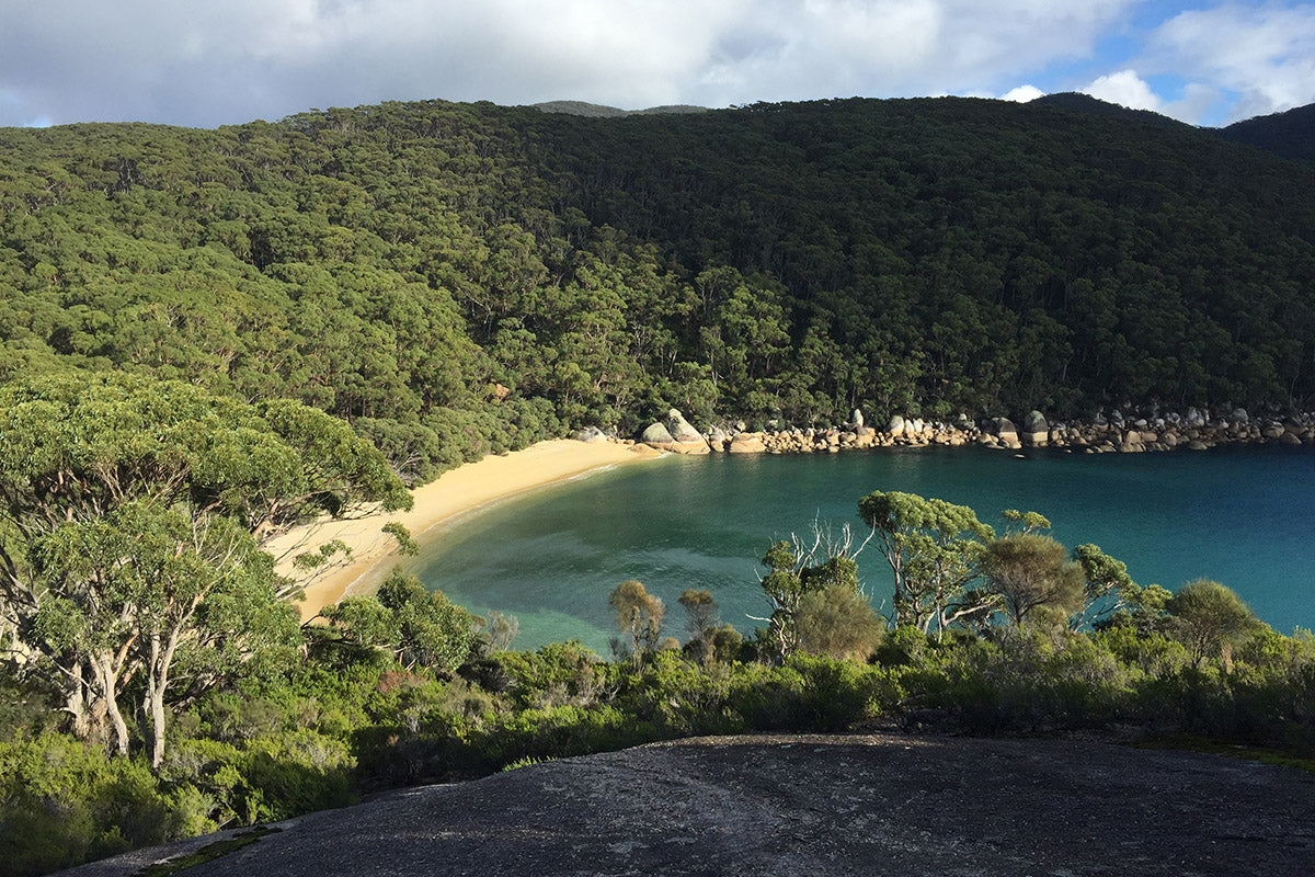
Wilson’s Promontory National Park
The Prom is located at the southernmost top of mainland Australia and consists of coastal trails and beautiful beaches surrounded by the granite peaks. With many family friendly camping areas, you can spend a night at the park and even be visited by the local wildlife. There are many walks of all difficulty levels at Wilson’s Prom, but we recommend the Mount Oberon Summit Walk for amazing panoramic views.
Location: 215km south east of the city (3 hrs drive)
Mount Oberon Summit Walk
Distance: 6.8km (2 hrs return)
Level of difficulty: Medium to hard
Tidal Overlook Circuit
Distance: 3.8km (1.5 hrs return)
Level of difficulty: Easy to medium
Find out more here.
Of course, before heading out any adventure make sure you’re prepared. Check the park is open or for any changes with Parks Victoria. Check the weather and make sure you pack water, sunscreen, a waterproof jacket and always tell a mate where you're going. Last but not least, leave no trace.
*Header image of Wilsons Promontory via @rhiannannaa