8 Spring Adventures Around Melbourne (And What to Pack)
Here are our top 8 spring adventures around Melbourne in 2025 - plus exactly what to pack so you’re comfortable, prepared, and free to enjoy it all.
Looking to get into the habit of hiking? Whether you're easing into the outdoors, walking the dog, or just craving some fresh air, here are 25 short hikes near Melbourne that are easy to get to - and even easier to fall in love with.
Yarra Bend is the largest natural bushland in Melbourne with kms and kms of trails, parklands, the popular Dights Falls and Flying Fox viewing platforms. Easy to get to and highly recommended.
The Darebin Creek Trail follows the Darebin Creek from the Main Yarra Trail in Alphington to Bundoora. Wide winding pathways, bridges, trees and parks along the way make this a picturesque trail.
Hays Paddock is known for the Glass Creek wetlands area plus having an archery range. There’s seating and tables, BBQ’s and public toilets making it an ideal picnic spot too.
Albert Park is popular with runners, cyclists and dog walkers with scenic views of the lake and incredible views of Melbourne’s skyline.
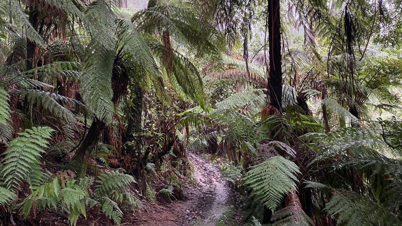
Warrandyte State Park is the closest state park to Melbourne’s CBD and has a range of trails for all levels of fitness. Think leafy trails and a variety of walks that feel much further from the city than it is.
Situated within Warrandyte State Park, the Mount Lofty Walk offers great views of surrounding hills and valleys and the chance to spot native wildlife. Whilst it mightn’t be the tallest at 122m, it still definitely gets your heart rate up.
The Sugarloaf Reservoir Circuit follows the perimeter of the Sugarloaf Reservoir, nestled in the Christmas Hills. There’s water views and possibility of kangaroo spotting. The Ironbark and Chris Phillips walks are shorter walks that can also be completed at the park.
The Sherbrooke Falls are located in the Sherbrooke Forest in the Dandenong Ranges National Park. Take the Sherbrooke Track or O’Donohue Track to get to the falls.
One of Melbourne’s most popular walks, the 1000 Steps Walk or Kokoda Memorial Walk is a must do. Whilst it’s debatable whether there are 1000 steps or not, it’s a beautiful hike amongst towering trees, ferns and greenery.
The Mullum Mullum Trail is a 42km circuit spanning from Templestowe and Donvale. Surrounded by bushland and native flora, the circuit links to the Koonung Main Trail and the Yarra Main Trail in Templestowe.
The Koonung Creek Trail follows a section of the Koonung Creek which borders Manningham, Whitehorse and Booronda. Wetlands and native wildlife can be seen on the trail. The Main Yarra Trail and EastLink Trail can also be accessed from here.
This cliff top trail covers the picturesque coastline and features art and history. It’s a must do on a sunny day or to find a spot for sunset.
Braeside Park is a large environmental park, with waterways, wetlands and heathlands. With easy trails popular with walkers and trailer runners.
At the foothills of the Dandenong Ranges, Lysterfield Park is a large park with for walkers and mountain bikes, it’s also a popular picnic spot and is well known for its wildlife. We recommend the lake circuit trial.
If you’re lucky enough to live on the Peninsula, you might have already been to the lighthouse, but perhaps not completed the full walk between Cape Schank and Bushrangers Bay. It’s an incredible walk along the coastline with beach access too.
A historic landmark at the tip of the Mornington Peninsula, well known for its Quarantine Station, tunnels, forts and gun towers from WW1 and WW2. An incredibly scenic hike combining beaches and history.
The view from Arthurs Seat extends across the Port Phillip Heads and on clear days as far as the You Yangs and Mt Macedon. An easy incline walk through gardens, picnic spots and lookouts.
Connecting Red Hill and Merricks, the rail trail is an old railway line, now frequented by hikes and horseriders. A hidden, yet enjoyable and easy trail with great cafes and towns at both ends.
This trail begins near the Westgate bridge and takes you past the historical maritime precinct of Williamstown, plus botanical gardens and beaches, popular for walkers and cyclists.
The Maribyrnong River Trail follows the river through the north-western suburbs of Melbourne. The trail passes wetlands, bush and residential areas, with some great views along the way.
What was previously derelict industrial land has been transformed into a picturesque hiking trail. With metre high artworks by Brooklyn artist Geoffrey Ricardo the Kororoit Creek Trail is a uniquely Melbourne trail.
The Brimbank Park Trail follows the Maribyrnong River and links to the Maribyrnong River Trail. The main circuit is 4.3km but the connection makes it possible to continue along the river as far as Footscray.
The Organ Pipes National Park has a variety of easy walking tracks and picnic spots just 20km outside of Melbourne. They’re a unique sight, with the Organ Pipes being formed by cooling and cracking volcano lava.
The Moonee Ponds Creek Trail begins at Melbourne’s Docklands and follows the creek to the Melbourne Airport following the creek. The trail has both open grasslands and bush, as well as playgrounds, rivers and bridges and multiple route options.
This trail is frequently populated by runners, walkers and bird watchers, being well sign posted and with the chance to see wildlife, with most of the trail being a vehicle path.
Found the perfect hike? It's time to make sure you've got the right gear to keep you protected from the elements, get your fit sorted here, and don't forget to pack some water, sunscreen and a windproof, waterproof jacket!
Want to visit without a car? Check out these best hikes near Melbourne by public transport.
